

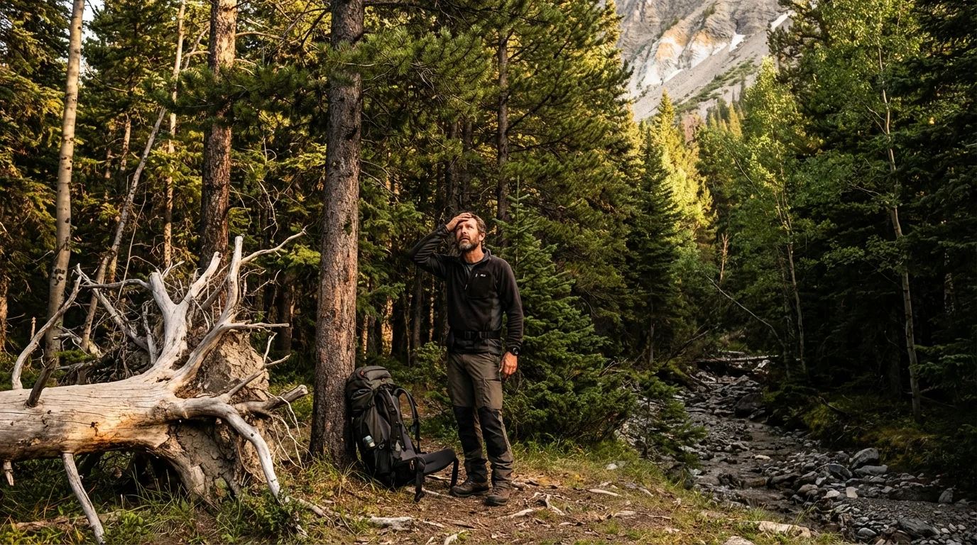
You’ve driven three hours, hiked six miles, and the light is going fast. There is a flat clearing right there, perfectly sized for your tent, and your feet are telling you to stop. This is exactly the moment when campsite selection errors happen. Not from ignorance, but from fatigue-driven decision shortcuts that skip the 10-minute hazard assessment that stands between a good night’s sleep and a genuine emergency.
I have walked people out of bad situations that started with campsite selection decisions made in the last 30 minutes of daylight. A tree that looked solid from the ground had a compromised root plate. A beautiful sandy flat beside a creek became 18 inches of moving water at 2 AM after rain that fell 40 miles upstream. A rocky ledge that provided what felt like perfect wind shelter was directly below an active rockfall chute. Every one of those situations was readable before the tent went up. Nobody read it.
This guide teaches you how to read it. Campsite selection is a systematic skill, not an instinct, and it produces reliable results when applied consistently regardless of how tired you are or how good that flat clearing looks.
Why Campsite Selection Is a Safety Decision, Not a Comfort Decision
Most camping resources frame campsite selection as a question of comfort: flat ground, good views, proximity to water. All of those things matter. But campsite selection is first and foremost a safety decision, because the consequences of getting it wrong range from a wet sleeping bag to a fatal outcome, and the assessment that prevents both takes the same amount of time.
The hazards that cause serious injuries and fatalities at campsites fall into four independent categories: overhead hazards (falling trees and branches), hydrological hazards (flooding and drainage failure), geological hazards (rockfall and unstable slopes), and biological hazards (wildlife trails, insect habitat, and proximity to territorial animal activity). A thorough campsite selection assessment addresses all four categories in sequence before a single stake goes into the ground.
Experienced backcountry travelers develop this assessment as an automatic habit that runs in the background of every site evaluation. They walk into a potential campsite and their eyes go up first (overhead hazards), then scan the skyline and surrounding terrain (geological hazards), then examine the ground and immediate surroundings (hydrological indicators and biological signs), and finally evaluate the practical factors of pitch placement, wind direction, and morning sun orientation. The sequence is not arbitrary. It follows the probability-weighted order of the hazards most likely to cause harm in most camping environments.
Understanding campsite selection as a structured assessment process rather than a gut-feel decision is the foundation of the systematic approach to pre-trip and on-site safety covered in the solo camping safety guide, where campsite selection is identified as one of the eight critical safety phases for campers operating without a partner to catch their errors.
The Overhead Hazard Assessment: Reading Widowmakers
The term “widowmaker” covers any dead, dying, or structurally compromised overhead material that can fall onto a campsite without warning. The name is accurate: falling trees and large branches kill campers every year in established campgrounds and backcountry sites, and the majority of those fatalities occur because nobody looked up during campsite selection.
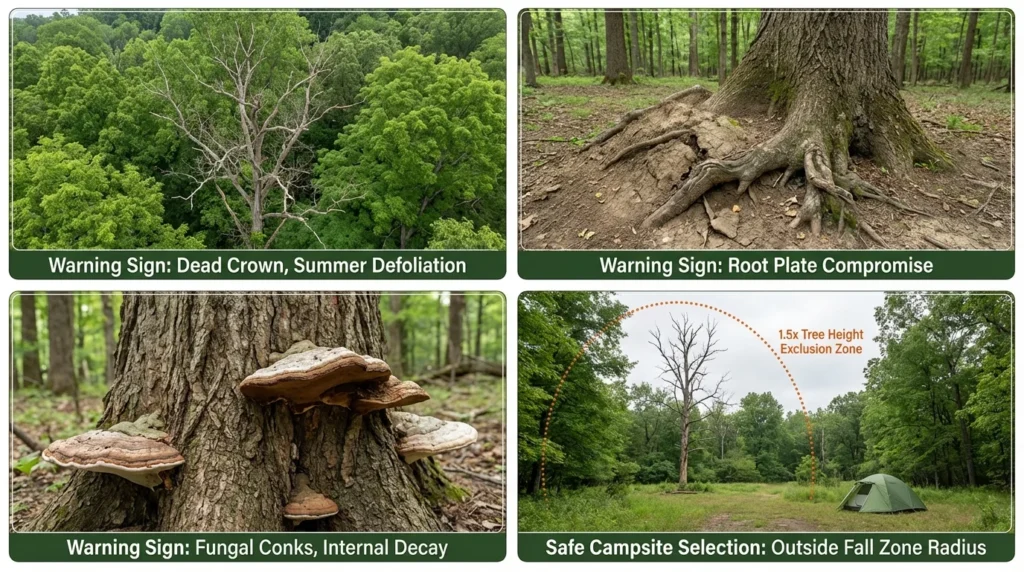
Identifying dead and dying trees requires looking at the crown first, not the trunk. A tree that is dead or dying typically shows the loss of fine branches and leaf coverage at the crown extremities before the structural compromise becomes obvious at the trunk level. A deciduous tree in summer with bare upper branches while neighboring trees are fully leafed is showing early stress signals. A conifer with rust-colored or gray needle coverage in patches rather than uniform green is a stressed or dead tree. Both are campsite selection exclusion criteria when the tree stands within fall distance of any potential sleeping area.
Fall distance is consistently underestimated by campers making campsite selection decisions. A standing tree falls to a length roughly equal to its height, and larger trees in forest settings can be 80 to 120 feet tall. The “just don’t camp under the dead tree” instinct that most campers have does not account for the tree that is 70 feet away and 75 feet tall. The correct campsite selection procedure is to identify all dead or compromised trees within a radius equal to 1.5 times the height of the tallest tree in the immediate area, and to ensure the tent footprint falls outside the fall zone of every identified hazard.
Root plate compromise is the failure mode that causes living, apparently healthy trees to fall without warning during windstorms and sometimes in calm conditions. Look at the base of large trees within the campsite selection assessment zone for soil mounding on one side of the base (indicating the root plate is beginning to lever out of the ground), visible root exposure on the upslope side, fungal conks (shelf mushrooms) growing from the root zone or lower trunk (indicating internal wood decay), and leaning that is progressive rather than the natural lean of a tree growing toward light.
Dead branches and hangers require looking up along the full length of every tree overhead, not just at the crown. A dead branch 40 feet up, held in the canopy by other branches rather than attached to its tree, is a “widow hanger” that can release from vibration, wind, or for no apparent mechanical reason. Any dead branch overhead within the tent footprint zone is a campsite selection disqualification regardless of how secure it appears.
In windy conditions, increase the campsite selection exclusion radius for all overhead hazards. Wind is the primary trigger for branch and tree falls, and a site that appears safe in calm conditions may be actively shedding material within 20 minutes of wind arriving. If wind is forecast or building, extend your campsite selection overhead clearance zone beyond the calculated fall distance and prioritize open ground over forest shelter.
Hydrological Hazard Assessment: Reading Water Risk
Water is the most frequently underestimated hazard in campsite selection because the most dangerous water scenarios (flash floods, overnight drainage events) are often completely invisible at the time of site assessment.
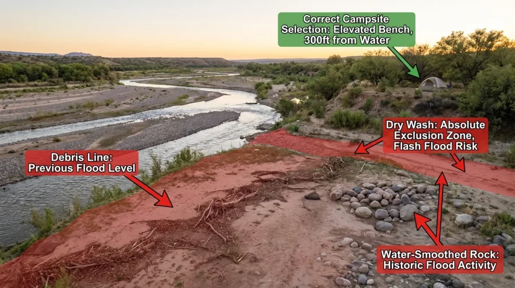
Identifying flood plains begins with terrain reading rather than direct water observation. Flood plains are defined by their flatness relative to the surrounding terrain: they are the areas that rivers and streams have historically occupied and will occupy again during high-water events. Any flat area adjacent to or between water features, regardless of how far the current water level is from the camping area, is a potential flood plain and requires specific campsite selection scrutiny.
Signs of historical flood activity that confirm flood plain status during campsite selection: debris lines (accumulations of sticks, leaves, and organic material at consistent elevation across the campsite) indicating previous water level, water-smoothed rocks or pebbles in an area that currently looks dry, the absence of established plant root systems in sandy or gravelly soil (indicating that periodic flooding prevents root establishment), and bent-over vegetation at consistent height showing the direction of historical water flow.
Dry creek beds and washes are the campsite selection hazard that kills most reliably, because they present as the most appealing camping spots in desert environments (flat, sandy, sheltered) while being among the most dangerous in any weather system. A dry wash in the American Southwest, the Australian outback, or any semi-arid environment can carry 3 to 5 feet of fast-moving water within 20 to 30 minutes of a storm that fell many miles away and produced no visible weather at the campsite location itself. Never camp in a dry creek bed or wash regardless of how dry the conditions appear or how stable the weather looks.
Drainage assessment at the campsite selection level looks at where water will go when it falls on the site during rain. Stand in the center of the potential campsite and look at the ground plane carefully. Is the site in a bowl or depression that will collect water? Does it slope toward the tent footprint from any direction? Are there natural channels (subtle linear depressions in the ground) that direct runoff across the site? The correct campsite selection ground geometry is a site with a gentle uniform slope of 2 to 5 degrees away from the tent footprint in all directions, allowing rain to sheet off rather than pool.
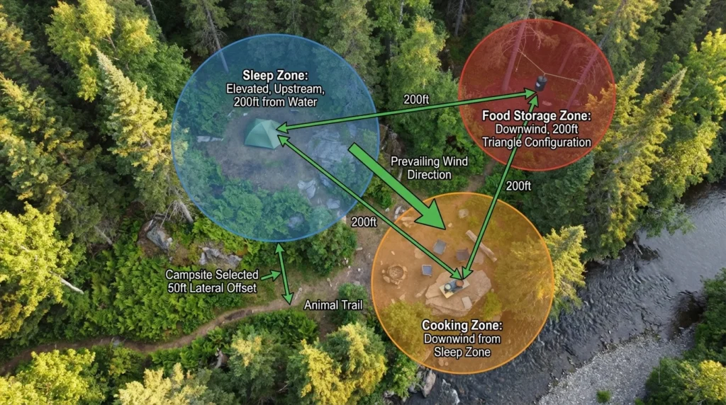
Distance from water sources in campsite selection serves both safety and wildlife avoidance functions. The Leave No Trace standard of 200 feet minimum from any water body is a baseline, not an optimal distance. In heavy rain terrain, canyon environments, or areas with unpredictable upstream catchments, 300 to 400 feet from the current water line provides meaningful additional safety margin. Choose the uphill side of a water source rather than the downstream side when campsite selection geography allows, as upstream positions are protected from water level rise that affects downstream positions.
The flooding identification and drainage management principles that govern campsite selection in wet terrain connect directly to the cooler and camp equipment placement principles in the camper cooler fridge gasket care guide, where ground moisture management and elevation off wet surfaces apply the same water avoidance logic to equipment protection.
Geological Hazard Assessment: Reading Rockfall and Slope Risk
Rockfall and slope instability are the campsite selection hazards with the most dramatic failure modes and the most readable warning signs, yet they are consistently underassessed by campers who are drawn to dramatic rocky terrain for its scenic value without evaluating its overhead risk.
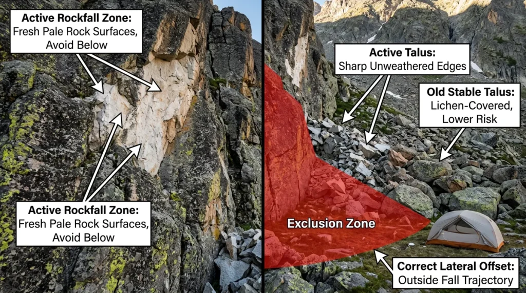
Identifying active rockfall zones requires looking at the terrain above the campsite selection area, not just the immediate ground level. Any cliff face, rocky slope, or boulder field above the potential campsite is a rockfall hazard source. The indicator of an active versus stable rockfall zone is fresh rock surface exposure: rocks that have recently detached show bright, unweathered surfaces compared to the lichen-covered, dark-patinated surfaces of stable rock that has not moved in years. A cliff face with multiple areas of fresh pale rock exposure is an active fall zone. A consistent deposit of sharp-edged rock fragments at the base of a slope (talus) indicates ongoing rockfall activity from above.
Talus and scree assessment in campsite selection looks at both the material characteristics and the deposit geometry. Fresh talus with sharp, unweathered edges indicates recent and ongoing rockfall. Rounded, weathered talus with established lichen and plant growth indicates an older, more stable deposit. Camp away from the base of any talus slope, with a lateral offset that places the tent outside the natural fall trajectory from the most common fall initiation points above.
Undercut banks and overhanging terrain in campsite selection require looking at the terrain profile from the side. An undercut bank above a riverbed or an overhanging rock section directly above a potential campsite represents a campsite selection disqualification regardless of how solid the material appears. Freeze-thaw cycles, root intrusion, and water saturation of clay-rich soil can cause undercut and overhang failures without visible warning signs, and these failures are characteristically large-volume events.
Slope angle and soil stability assessment in campsite selection uses a simple physical test: stand on the slope and stamp your heel firmly into the soil. Soil that compresses and holds your heel print is stable and adequately consolidated for camping. Soil that shears or slides under heel pressure, or that produces a hollow sound under impact, is unstable consolidated material that may not support a tent stake system adequately and may be prone to small-scale slides during rain.
Biological Hazard Assessment: Reading Animal Sign
Wildlife activity patterns around a campsite selection area determine both the probability of wildlife encounters during the night and the long-term safety of the camp food management system. Reading biological hazard signs during campsite selection takes less than five minutes and dramatically reduces wildlife encounter risk.
Animal trail identification during campsite selection looks for linear wear patterns in the ground vegetation, soil compaction along narrow pathways, and the directional flattening of grass or low plants that indicates repeated foot traffic. Animal trails leading to or through a potential campsite selection area indicate regular wildlife movement through that location, typically related to water source access, food source access, or territorial patrol routes. Camping directly on or adjacent to an active animal trail increases encounter probability substantially.
Scat and track assessment within the campsite selection evaluation zone identifies the species using the area recently. Bear scat (typically large, berry-seed or hair-containing deposits), large cat scratch marks on tree bark at shoulder height, and large ungulate tracks all indicate species that warrant specific behavior and food storage protocols. Fresh scat (moist, strong-odored) indicates recent presence and should prompt reconsideration of the campsite selection location entirely or at minimum immediate implementation of strict food security protocols.
Insect and ground hazard assessment during campsite selection looks for the yellowjacket and wasp ground nests that produce the most common wildlife-related medical emergencies at campsites. Look for flight activity entering and exiting soil-level holes in the ground, particularly in dry, sandy soil. A campsite selection area with active yellowjacket ground nest activity should be abandoned entirely: a single disturbed nest during the night can produce a mass-stinging event with severe medical consequences.
The wildlife management protocols that follow from biological hazard assessment during campsite selection are covered in full in the solo camping safety guide, where bear spray carry protocols, three-zone camp architecture, and snake awareness are addressed as the behavioral response to the biological hazards this section identifies.
Wind Exposure and Microclimate Assessment
Wind exposure is a campsite selection variable that affects both safety and sleep quality, with safety consequences in extreme wind events that inexperienced campers underestimate significantly.
The correct campsite selection wind assessment evaluates both the current wind conditions and the terrain features that will determine wind behavior during the night and following morning. Wind in mountainous terrain does not behave like wind in flat environments: it accelerates through saddles and passes, reverses direction in valleys after sunset as cold air drainage flows downhill, and creates unpredictable turbulence behind ridge features that appear to offer shelter from the obvious wind direction.
Cold air drainage is the campsite selection microclimate factor that produces the “why is it so much colder here than anywhere else” experience that campers in valley and hollow sites report. Cold air is denser than warm air and flows downhill after sunset, collecting in valley bottoms, hollows, and terrain depressions. Campsite selection in the lowest point of a valley or basin consistently produces sleeping temperatures 5 to 15°F colder than adjacent higher terrain, in addition to the drainage flooding risk described earlier. The converging bad outcomes of cold air pooling and drainage concentration make valley bottoms one of the worst campsite selection locations in any terrain type.
Natural windbreak assessment during campsite selection distinguishes between sheltering features that reduce wind load on the tent and exposure features that increase it. A dense stand of healthy trees on the windward side of the campsite selection area provides effective wind reduction. An isolated large tree or boulder on the windward side creates turbulence and eddy effects that may be worse than open exposure. A ridge line directly upwind creates acceleration and turbulence on the lee side that can exceed the wind speed in the open.
The tent staking, footprint, and weather resistance considerations that govern how well your shelter performs in the wind conditions your campsite selection exposes it to are covered in detail in the tent accessories guide, where upgraded stake systems, guy line configurations, and footprint protection are evaluated for exposed campsite use specifically.
The Complete Campsite Selection Assessment Checklist
A systematic campsite selection assessment covers all five hazard categories in a consistent sequence that takes 10 to 15 minutes for a thorough evaluation of any site.
Step 1: Overhead Assessment (2 to 3 minutes)
- Identify all trees within 1.5x the height of the tallest tree overhead
- Check each for dead crown material, structural lean, root plate compromise, and fungal sign
- Mark any trees with dead hangers or fall-zone overlap with the tent footprint as exclusion criteria
- Check cliff faces and rocky slopes above for fresh unweathered rock exposure
Step 2: Hydrological Assessment (3 to 4 minutes)
- Confirm the site is at least 200 feet from any water body (300 to 400 feet in canyon and high-rain terrain)
- Look for debris lines, water-smoothed rock, and bent vegetation indicating flood history
- Assess ground slope geometry for drainage away from tent footprint
- Confirm no drainage channels cross the tent footprint area
- Verify the site is not in a dry creek bed, wash, or terrain depression
Step 3: Geological Assessment (2 to 3 minutes)
- Examine terrain above the site for talus, cliff faces, and overhang features
- Check talus for fresh unweathered surfaces indicating active rockfall
- Test soil stability with heel-stamp test
- Confirm no undercut banks or overhanging terrain directly above the tent footprint
Step 4: Biological Assessment (2 to 3 minutes)
- Walk the campsite perimeter looking for animal trail linear wear patterns
- Check for scat, tracks, and scratch marks indicating recent wildlife presence
- Scan ground level for yellowjacket nest flight activity
- Assess distance from berry patches, nut-producing trees, and water sources that attract wildlife
Step 5: Microclimate Assessment (2 minutes)
- Assess valley-bottom versus elevated terrain position for cold air drainage
- Identify wind direction and evaluate natural windbreak quality
- Confirm tent door orientation away from prevailing wind
- Check for turbulence-producing isolated terrain features upwind
The systematic pre-trip and on-site assessment framework that this campsite selection checklist integrates with is the foundation of the complete gear and safety preparation approach covered in the camper maintenance checklist guide, where equipment condition, campsite planning, and hazard awareness are treated as a unified pre-departure system.
Campsite Selection Hazard Quick Reference
| Hazard Type | Primary Indicator | Exclusion Criterion | Safe Distance |
|---|---|---|---|
| Widowmaker tree | Dead crown, fungal conks, root mounding | Any dead tree in fall zone | 1.5x tree height radius |
| Dead branch hanger | Dead wood held in canopy, not attached | Any dead overhead branch | Full branch fall radius |
| Flood plain | Debris lines, smooth rock, no root establishment | Any flat ground adjacent to water | 200 to 400 feet from water |
| Dry creek bed or wash | Sandy flat channel, no rooted plants | Absolute exclusion, no exceptions | Never camp in any wash |
| Active rockfall | Fresh pale unweathered rock face above site | Any active fall zone overhead | Outside fall trajectory |
| Animal trail | Linear soil wear, directional vegetation flatten | Trail crossing tent footprint | 50 feet minimum lateral offset |
| Ground nest insects | Flight activity entering soil holes | Active nest in campsite area | Abandon site entirely |
| Cold air drainage | Valley bottom, hollow, terrain depression | Not exclusion, but significant cold penalty | Use elevated terrain instead |
| Unstable slope | Heel-stamp soil shear, hollow sound | Soil failing heel-stamp test | Seek consolidated ground |
Campsite Selection Hazard Risk Visualization
To help you understand which hazards demand the most immediate attention during campsite selection, here is a risk priority framework based on consequence severity and assessment difficulty:
Highest consequence, hardest to detect:
Widowmaker trees and root plate failures, active rockfall zones, and flash flood zones top this category because they produce fatal outcomes and the warning signs are easy to miss in poor light or when fatigued.
High consequence, easier to detect:
Dry creek beds, flood plains with visible debris lines, and obvious animal sign are high-consequence hazards with clearly readable indicators that campsite selection assessment reliably catches.
Moderate consequence, easy to detect:
Ground nest insects, cold air drainage hollows, and poor drainage geometry are detectable with basic observation and produce manageable outcomes when missed, though they can escalate in specific scenarios.
Frequently Asked Questions About Campsite Selection
Q: How far from a river or stream should I camp for flood safety?
The Leave No Trace standard minimum is 200 feet from any water body, but for campsite selection in canyon terrain, areas with upstream catchments that can generate flash floods, or anywhere with a forecast weather system in the region, 300 to 400 feet from the current water line is the correct distance. Always camp on the uphill side of a water source relative to the current water level. A river that is currently 3 feet below its banks in a narrow canyon can rise to bank-full within 30 minutes of significant upstream rainfall that produced no weather at your campsite location.
Q: What is a widowmaker and how do I identify one during campsite selection?
A widowmaker is any dead, dying, or structurally compromised tree or large branch that has the potential to fall onto a campsite. During campsite selection, identify widowmakers by looking at the crown first: dead upper branches, patchy or absent leaf cover on a tree surrounded by healthy trees, rust-colored or gray conifer needles, visible fungal conks on the trunk or root zone, and soil mounding at the base indicating root plate movement. Any tree showing these signs within a radius of 1.5 times the height of the tallest trees in the area is a campsite selection exclusion criterion.
Q: Can I camp in a dry creek bed if the weather looks clear?
No. Dry creek beds and washes are absolute campsite selection exclusions regardless of current weather at the campsite location. Flash floods are generated by rainfall in the upstream catchment that may be many miles from your location and completely invisible from your campsite. A dry wash can go from completely dry to carrying 5 feet of fast-moving water in 20 to 30 minutes with zero warning. There is no weather observation you can make at the campsite location that reliably confirms a dry wash is safe for camping.
Q: How do I assess whether a campsite is on a flood plain?
Look for debris lines at consistent elevation across the site indicating previous water levels, water-smoothed rocks or pebbles in currently dry areas, sandy or gravelly soil without well-established plant root systems (indicating periodic flooding that prevents root establishment), and the directional flattening or bending of vegetation indicating historical water flow direction. These indicators are present regardless of how long ago the last flood event occurred and provide reliable campsite selection flood plain identification in most terrain types.
Q: What animal signs should make me choose a different campsite?
Fresh scat (moist, strong-smelling), large claw marks on tree bark at shoulder height, linear soil wear from regular animal trail use crossing the campsite footprint, and bear dig sites (areas of disturbed soil where bears have excavated for food) are all campsite selection indicators that warrant either moving to an alternative site or implementing strict food security and bear deterrent protocols immediately. Ground-level flight activity into soil holes indicates yellowjacket or wasp ground nests that are a campsite selection disqualification because a disturbed nest at night produces a mass-stinging event with potentially severe medical consequences.
Q: What is the safest terrain feature for campsite selection in mountainous areas?
A slightly elevated, flat to gently sloping bench or terrace above valley bottom but below ridge line provides the optimal campsite selection terrain in mountainous environments. This position avoids cold air drainage in the valley bottom, avoids wind acceleration and turbulence on the ridge line, provides natural overhead clearance from rockfall and widowmaker hazards, drains water effectively without pooling, and positions the campsite above flood plain elevation while remaining accessible from the trail. In practice, these benches and terraces are the terrain features that experienced backcountry travelers identify and move toward as default campsite selection targets in complex mountain terrain.
Q: How much time should a proper campsite selection assessment take?
A complete campsite selection hazard assessment covering all five categories (overhead, hydrological, geological, biological, and microclimate) takes 10 to 15 minutes for a thorough evaluation. This is the correct time investment regardless of how late the light is, how tired you are, or how obviously suitable the site appears from the trail. The campsite selection errors that produce serious outcomes are almost always made in the last 30 minutes of daylight under time pressure when the assessment is compressed or skipped. Planning your daily mileage to arrive at camp with 45 to 60 minutes of useful light remaining eliminates the time pressure that drives poor campsite selection decisions.